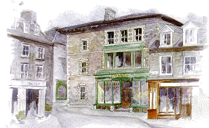
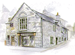
 1 The
imposing building (ca. 1886) of T.H. Roberts is a remarkably
well preserved ironmonger's which still has its original fittings. At the turn of the century
over 500 gold miners were employed around Dolgellau; many of their picks
and shovels must have come from here. A much older building, Cwrt
Plas yn Dre, once stood on the site, and was reputedly a meeting
place for the famous Welsh rebel Owain Glyndwr who temporarily
controlled mucy of Wales in the early 1400s. Despite being the town's
chief tourist attraction, the building was demolished in 1881. Parts
were re-erected in Newtown. 1 The
imposing building (ca. 1886) of T.H. Roberts is a remarkably
well preserved ironmonger's which still has its original fittings. At the turn of the century
over 500 gold miners were employed around Dolgellau; many of their picks
and shovels must have come from here. A much older building, Cwrt
Plas yn Dre, once stood on the site, and was reputedly a meeting
place for the famous Welsh rebel Owain Glyndwr who temporarily
controlled mucy of Wales in the early 1400s. Despite being the town's
chief tourist attraction, the building was demolished in 1881. Parts
were re-erected in Newtown.
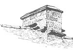
2 By
the mid 19th century Dolgellau had its own gas supply produced from
burning coal. The retort house remains,
though its chimney stack has been removed and slated over. Gas was
stored in gasometers behind the works. The small building to the right
was the governor house.
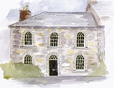
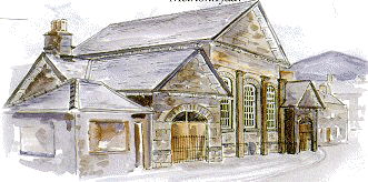 3 Arguably
the finest architect designed building in the town, the County
Hall, was built in 1825 at a cost of £3,000. The
architect was Edward Haycock. This was the administrative headquarters
of Meirionnydd in the 19th century. Its role as a court house continues
to this day. The porches were filled in in 1995, spoiling the simple
elegance of the building. The slate in front is something of a mystery.
At first sight it appears to be a milestone; the mileage figures were,
however, carved at a later date. It may have originally recorded
stagecoach fares. 3 Arguably
the finest architect designed building in the town, the County
Hall, was built in 1825 at a cost of £3,000. The
architect was Edward Haycock. This was the administrative headquarters
of Meirionnydd in the 19th century. Its role as a court house continues
to this day. The porches were filled in in 1995, spoiling the simple
elegance of the building. The slate in front is something of a mystery.
At first sight it appears to be a milestone; the mileage figures were,
however, carved at a later date. It may have originally recorded
stagecoach fares.
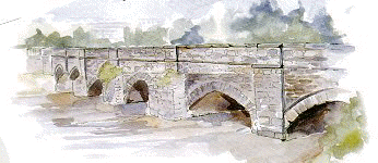 4 The
bridge was built in 1638 (the date is on the downstream side) and has
since been widened and extended. It is called Y
Bont Fawr (the Big Bridge) to distinguish it from a
smaller bridge that lay just to the south. Dolgellau has suffered from
many floods. One major flood in 1903 destroyed part of the bridge. The
top end of Bont Fawr was raised to accommodate the railway which ran on
the line of the present bypass. The station was just upstream of the
bridge. Initially (1868) through-passengers were obliged to change as
two rival railway companies, each with its own terminus, met here. The
journey from London took eight and a half hours in the 1870s. By the
1930s it was down to five and a half hours, a journey time it would be
hard to equal by today's public transport. 4 The
bridge was built in 1638 (the date is on the downstream side) and has
since been widened and extended. It is called Y
Bont Fawr (the Big Bridge) to distinguish it from a
smaller bridge that lay just to the south. Dolgellau has suffered from
many floods. One major flood in 1903 destroyed part of the bridge. The
top end of Bont Fawr was raised to accommodate the railway which ran on
the line of the present bypass. The station was just upstream of the
bridge. Initially (1868) through-passengers were obliged to change as
two rival railway companies, each with its own terminus, met here. The
journey from London took eight and a half hours in the 1870s. By the
1930s it was down to five and a half hours, a journey time it would be
hard to equal by today's public transport.
 5 The
now defunct Golden
Lion Inn
was once a coaching inn. The stagecoach journey from London took about
twenty-four hours ca. 1830. It became the premier hotel of the area and
was an obligatory stopping point for any passing European royals. 5 The
now defunct Golden
Lion Inn
was once a coaching inn. The stagecoach journey from London took about
twenty-four hours ca. 1830. It became the premier hotel of the area and
was an obligatory stopping point for any passing European royals.
6 One
of the very few brick
buildings
in Dolgellau and unique for its period (early 19th century). Note that
the bricks were only used on the principal elevation.
 7 The
Old Town Hall (Y
Sosban), dated 1606, once fulfilled the judicial and administrative
functions of the town. Two dungeon-like rooms downstairs served as a
lock-up for vagrants and drunkards. 7 The
Old Town Hall (Y
Sosban), dated 1606, once fulfilled the judicial and administrative
functions of the town. Two dungeon-like rooms downstairs served as a
lock-up for vagrants and drunkards.
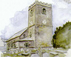
8 The
present Church (St Mary)
dates from 1716, with a chancel added in 1864. The masonry is,
unusually, of dressed slate with blocks overlapping at the corners,
log-cabin style. The timber piers inside were brought over the mountains
by ox-cart from Dinas Mawddwy. A carved stone effigy (ca. 1350) of
Meurig ap Ynyr Fychan lies in the NE corner of the church. The first
mention of the church and indeed of Dolkelew is from 1253. The
Cistercian Cymer Abbey (founded 1198) two miles away, was the main
religious centre and a major influence until its suppression in 1536.
 9 Tan
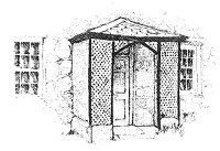
y Fynwent This
fine town house dating from the late 17th century was the rector's
residence at one time and was possibly built as such. Note the unusual
positioning of the chimneys and the 19th-century lattice-work porch.
Such porches are one of the characteristic architectural features of the
town. 9 Tan
y Fynwent This
fine town house dating from the late 17th century was the rector's
residence at one time and was possibly built as such. Note the unusual
positioning of the chimneys and the 19th-century lattice-work porch.
Such porches are one of the characteristic architectural features of the
town.
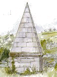 10 Dolgellau's
own pyramid, a monument to local bard and schoolteacher Dafydd Ionawr
(1750-1827). 10 Dolgellau's
own pyramid, a monument to local bard and schoolteacher Dafydd Ionawr
(1750-1827).
11 The
Marian Dolgellau's
main green space and one of its greatest assets, was given in trust to
the town in 1811. It has been the focus of the town's leisure activities
for generations. By the 16th century there was a bowling green
surrounded by ditches to keep out grazing animals. It lay under the car
park. A hollow in the grass in the cricket outfield marks the site of a
cockpit. The stone circle was set up in 1948 to proclaim the National
Eisteddfod of Wales the following year. Using stone-age technology for
advertising in this way is a peculiarly Welsh phenomenon.
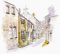 12 The
Lawnt is
the historical centre of Dolgellau. We can imagine the first settlement
grew up around the slightly raised ground in the area of the Church. The
Lawnt is now a residential area but as you walk through you will see
evidence of former commercial activity such a shop windows. Hope House
(no.4) on your right was a woollen factory. A little further up the road
on the left, the building with the tall window was Dolgellau's first
bank, established in 1803. 12 The
Lawnt is
the historical centre of Dolgellau. We can imagine the first settlement
grew up around the slightly raised ground in the area of the Church. The
Lawnt is now a residential area but as you walk through you will see
evidence of former commercial activity such a shop windows. Hope House
(no.4) on your right was a woollen factory. A little further up the road
on the left, the building with the tall window was Dolgellau's first
bank, established in 1803.
 13 The
former police
station
dates from the mid 19th century. Its delicate Gothic windows present a
very different image of the law from that of the modern police
headquarters across the river. 13 The
former police
station
dates from the mid 19th century. Its delicate Gothic windows present a
very different image of the law from that of the modern police
headquarters across the river.
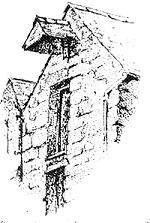
14 The toll house
of the former turnpike road to Tywyn. The toll keeper's viewing window
can be seen in the right hand corner of the gable elevation, with the
stone post for the tollgate adjacent.
 Each
of the roads from the town was turnpiked at one stage. Turnpikes were
extremely unpopular in Wales and caused riots in the 1830s. Each
of the roads from the town was turnpiked at one stage. Turnpikes were
extremely unpopular in Wales and caused riots in the 1830s.
15 At
the height of the religious revival at the beginning of the 20th century
Dolgellau had about ten chapels.
Their services, Sunday schools, prayer meetings and bible readings were
a major social focus of the town. In 1829 the Sunday School at Salem
Chapel had 400 children and 71 teachers. The main chapels were largely
rebuilt in the late 19th century (Tabernacl 1868, Salem 1893, Ebenezer
1880, Judah 1839/1928). Several chapels have been converted to other
uses recently; a post office, a theatre, a dental surgery.
 16 The large stones
embedded at the foot of the wall on the left protected it from the hubs
of passing carts. 16 The large stones
embedded at the foot of the wall on the left protected it from the hubs
of passing carts.
17 The
cast-iron gates
to Bryn Ffynnon which you pass on the right were made in Wolverhampton
in the late 19th century. Bryn Mair, the adjacent house a little further
up the hill, also has a grand entrance. The finely dressed gate pillars
of the intractable local dolerite are a testament to the craftsmanship
and patience of the mason.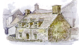
18 Viewpoint over the town. Most of the prominent buildings outside the
historic centre are publicly owned. The mountain in the background to
the far right is Aran Fawddwy. Moel Offrwm is directly opposite, and Y
Garn and Diffwys lie to the left beyond the Mawddach estuary.
19 Ffynnon
Plas Ucha is one of several springs in this part of
town. Now almost forgotten, this perennial source of clean water used to
be an important resource for local residents.
20 Y
Domen Fawr (Meyrick Square). The name suggests a dump or
mound once stood here. In the early 19th century it was a crowded warren
of little houses, workshops, shops and "tippling houses". The
population density of the whole town used to be much higher. The 1801
census recorded 2,949 inhabitants. Today the population is slightly
lower but there are at least twice as many dwellings.
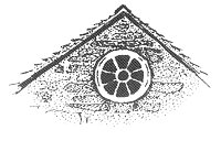 21 Tan
y Gader The birth place of many Dolgellau folk, this
house (built ca. 1800) was used as a maternity home. The
unusual wheel window in the attic gable can be seen in several houses of
similar age in the area. Note the pretty dormer bargeboards. 21 Tan
y Gader The birth place of many Dolgellau folk, this
house (built ca. 1800) was used as a maternity home. The
unusual wheel window in the attic gable can be seen in several houses of
similar age in the area. Note the pretty dormer bargeboards.
22 The
Catholic Church, completed in 1966, was the fulfillment
of a lifetime's dreams and efforts by local priest Francis Scalpell to
have a more noble structure for his church than a former chip shop. The
Maltese Cross to the left of the west door commemorates his Maltese
origins.
23 Fro
Awel is a typical vernacular cottage. The design, with
its low roof and hipped dormer windows, is typical of the mid 17th
century to mid 18th century. The rear wing was once a candle factory to
supply the gold mines.
24 Siop
y Seren was built in 1800 partly for commercial use with
a shop extension added later. Note the stone bridge at the back on the
second floor. This gave weavers access to the loom rooms in the upper
two storeys.
25 Wtra
Plas Coch The name wtra, used for a narrow
lane, comes from the Shropshire word "out-track", a farm road.
The Unicorn and Plas Coch (to its right) were built around 1700.
Originally they had steeply pitched roofs with dormers and tall
chimneys. In the early 1800s the roof level was raised (see gable end of
Plas Coch). The Clifton Hotel, next door, was rebuilt around 1820 from
the old town jail (1716-1813). John Howard, the penal reformer, visited
the jail in 1774 and commented on its filthy state. Little had improved
by 1788, when prisoners petitioned about the maggots and "nasty
filth" in the water which came from the river Aran where sheep
skins were washed.
 26 Bwthyn
Pont yr Aran A vernacular cottage of the 17th century.
Note the roof details: the slates laid in diminishing courses and the
inset stone slabs to shed the water away from the base of the chimney
stacks. These are a common feature in Dolgellau, which enjoys an annual
rainfall of around 70 inches. The ground floor is below road level. This
is also true of the older buildings along Wtra'r Felin, which leads from
here to the church. Perhaps this was the site of the road that led east
to the centre of the town. The buildings behind housed a fellmongering
business, where sheep pelt were processed. The business closed in 1989.
thus ending the long tradition of processing wool and sheep-hides in the
town. 26 Bwthyn
Pont yr Aran A vernacular cottage of the 17th century.
Note the roof details: the slates laid in diminishing courses and the
inset stone slabs to shed the water away from the base of the chimney
stacks. These are a common feature in Dolgellau, which enjoys an annual
rainfall of around 70 inches. The ground floor is below road level. This
is also true of the older buildings along Wtra'r Felin, which leads from
here to the church. Perhaps this was the site of the road that led east
to the centre of the town. The buildings behind housed a fellmongering
business, where sheep pelt were processed. The business closed in 1989.
thus ending the long tradition of processing wool and sheep-hides in the
town.
27 The
present bridge is
built on top of its much narrower predecessor. The view from
here is tranquil today but two hundred years ago it would
have been very different. The Aran was the power source that
drove the fulling machinery and later the carding and the
spinning mills. There were several fulling mills along its banks
where the cloth was beaten and washed to close up the fibres.
Tour writers of this time talk of the streams
"resounding" with the sound of the pounding wooden
mallets, and of the tenter racks where the cloth was then dried
and bleached "extending along the hills". The lengths
of hand-woven cloth, called webs, were around two
hundred yards long.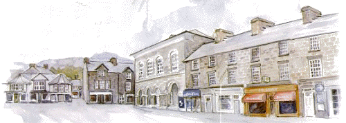
28 The
Square: meeting place,
market place, trading place, and the venue for fairs, community
events and festivals. It contains several buildings of interest.
Eldon Row to your right as you look up the Square was built in
1810. It was named for Lord Eldon who won a lawsuit for the
local squire.
 Neuadd
Idris above it was built in ca. 1870 as a market hall
(now converted to shops) with assemby rooms above. Plas Newydd,
at the top of the Square, dates from the17th century, with the
bays facing the Square added around 1800. Central Buildings, to
your left, was formerly a warehouse and shop for the locally
produced tweed. Ty Meirion used to be called London House. It
was an emporium for goods from a London merchant. Many Welsh
towns have their London, Liverpool or Manchester House. If you
go round the back of the building you can still see the hoist
and loading bay on the third floor. Ty Meirion now houses a
display on the Quakers. Their strong faith led to persecution
and many left to start a new life in Pennsylvania. The famous
American women's university of Bryn Mawr derives its name from a
Quaker farmhouse just above the town. Neuadd
Idris above it was built in ca. 1870 as a market hall
(now converted to shops) with assemby rooms above. Plas Newydd,
at the top of the Square, dates from the17th century, with the
bays facing the Square added around 1800. Central Buildings, to
your left, was formerly a warehouse and shop for the locally
produced tweed. Ty Meirion used to be called London House. It
was an emporium for goods from a London merchant. Many Welsh
towns have their London, Liverpool or Manchester House. If you
go round the back of the building you can still see the hoist
and loading bay on the third floor. Ty Meirion now houses a
display on the Quakers. Their strong faith led to persecution
and many left to start a new life in Pennsylvania. The famous
American women's university of Bryn Mawr derives its name from a
Quaker farmhouse just above the town.
|
|